Metadata

Metadata is information on the questions what, who, how, where, when concerning collected data and existing services. This allows them to be described and referenced unambiguously, which is necessary for targeted searching.
Their documentation is done by machine-readable (XML) standardized (ISO) descriptions, which are, among other things, applied in a search as filter criteria or displayed via information boxes as layer descriptions.
Core elements of metadata are:
Thus they enable:
The ISO 19115: Geographic information – Metadata standard has provided the generic structure for metadata in major national and international spatial data infrastructures since 2003. About a dozen ISO core elements form the basic framework for all types of metadata with which intersectoral searches can be realized. Sector-specific metadata profiles can extend this ISO core with individually required elements.
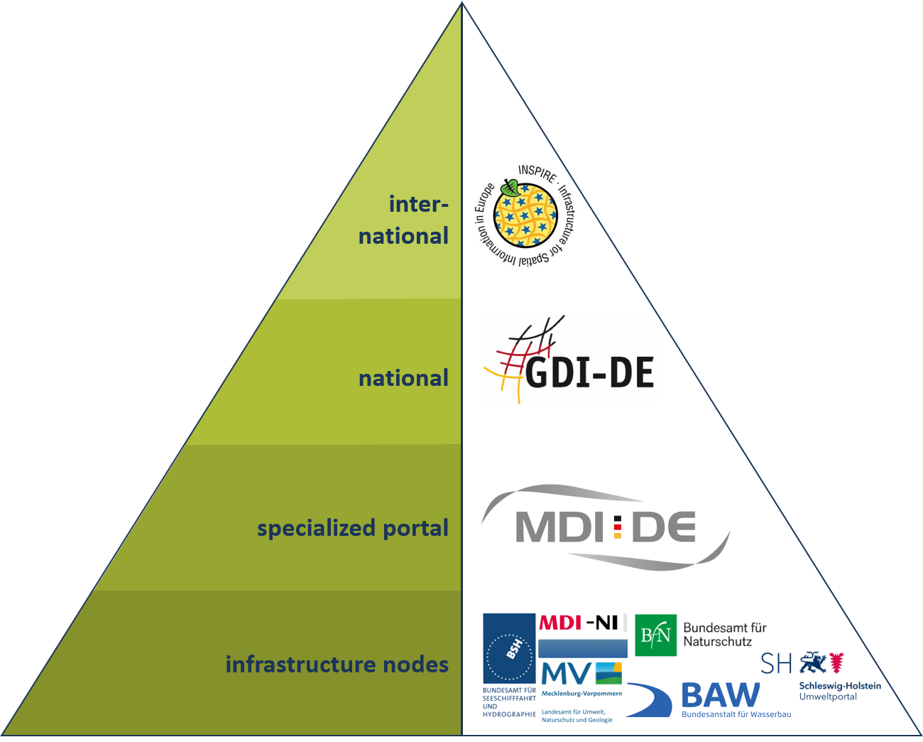
The Spatial Data Infrastructure Germany (GDI-DE) uses the core elements of ISO 19115 for the documentation of geodata. In order to be able to use this metadata in the INSPIRE geoportal as well, additional mandatory metadata entries are required. In addition, there is the Data Portal for Germany (GovData), in which the metadata standard for open administrative data DCAT-AP.de is binding.
Metadata are the central basic elements on which the functionality of the MDI-DE geoportal for searching and providing quality-assured official data with standardized services is based. This is described in a guideline for the maintenance and creation of metadata in the MDI-DE (Wosniok and Räder, 2013).
In the MDI-DE Coastal Zone Profile, many optional elements of the ISO standard are marked as mandatory to improve the documentation of coastal data. An overview of the metadata elements used at MDI-DE member agencies is provided in the publication “Metadata for the MDl-DE: The Evolution of the Coastal Zone Profile” (Wosniok and Lehfeldt, 2013).
Furthermore, the Coastal Zone Profile contains metadata elements from other existing profiles. Since the ISO 19115 standard provides for metadata extensions, these can be customized to meet specific needs of user communities. Thus, the common MDI-DE metadata model includes metadata elements for intertidal zone surveys as defined by the Federal Geographic Data Committee (FGDC 2001).
The MDI-DE partners maintain metadata for their own specialized data and services on the distributed infrastructure using different metadata systems with CSW interfaces. The metadata catalog developed as the North Sea and Baltic Sea Coastal Information System (NOKIS) implements the InGrid software platform as an editor for recording and as a research tool for searching metadata. Schleswig-Holstein and Lower Saxony use NOKIS, while Mecklenburg-Western Pomerania uses the MetaVer metadata network.
The MDI-DE metadata system bundles relevant geoinformation from the German coastal and marine regions into a central entry point for searching. A search with the MDI-DE thus evaluates the metadata on data and services holdings of a number of existing specialized portals and displays them in a common hit list.
Technically, metadata is regularly retrieved from the infrastructure nodes in an automated process called harvesting via a catalog interface (Catalog Service Web, CSW) and merged into a new catalog at the MDI-DE. In addition to the infrastructure nodes of the partner authorities, the MDI-DE harvests metadata from selected specialized portals with relevant coastal and marine information.
To ensure the discoverability of MDI-DE metadata in higher-level information systems such as the GDI-DE or INSPIRE, they are made available via CSW interfaces. Keywords from thesauri, such as the General Multilingual Environmental Thesaurus (GEMET), which is mandatory for INSPIRE, are used to control the visibility of metadata in hierarchically structured information systems (Herlé et al., 2021).
The Spatial Data Infrastructure Germany (GDI-DE) is the national target system in which information from the MDI-DE subject portal should be discoverable. It provides the currently valid recommendations for action and corresponding checking mechanisms for metadata as a test suite. All metadata published in the MDI-DE have successfully passed this quality assurance test and are consequently also evaluated in the INSPIRE portal.
Operators of their own metadata catalogs can also request the metadata directly via the CSW interface https://nokis.mdi-de-dienste.org/csw?service=CSW&request=GetCapabilities and retrieve them automatically.
The participating authorities, which operate the infrastructure nodes on their own are responsible for the maintenance of data and metadata inventories. This includes quality assurance and data updating as needed, without which the services provided quickly lose their relevance.
The software of the common metadata editors supports editors with help functions and menu navigation during the acquisition and maintenance.